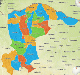
Katsina State

Katsina State, popularly known as the ‘Home of Heritage and Hospitality,’ was carved out of the defunct Kaduna State in 1987. It is not only the cultural pacesetter of the region; it is also the birthplace of the seven historic Hausa states that form the nucleus of what is today Northwest Nigeria. It was a center for commerce and education (Islamic and Western) and also a gateway for Trans-Saharan trades from North Africa through West Africa. Additionally, it is characterized as an agrarian economy and serves as a center for the Northwest Geopolitical zone. The State is bordered in the East by Kano State, in the West by Zamfara State, in the South by Kaduna State, and in the North by the Niger Republic.

Katsina State Snapshot

  • Area around 24,192 sq km.
  • Local Government Areas: 34 LGAs
  • Population: 8,315,581 (Male- 4,240,946 and Female- 4,074,635)
  • Vegetation: Tropical Savannah
  • Major crops: Cotton, Sorghum, Sugarcane, Tomato, Soybean, Onion.
  • Solid minerals: Basalt, Diamonds, Feldspar, Granite, Graphite, Gold, Iron-Ore, Kaolin, Manganese, Nickel, Uranium.
  • GDP (PPP) of USD 6,022 million and GDP per capita of USD 1,017 in 2010
  • Important place for sub-saharan trade due to its proximity with Niger Republic
  • Large 2.4 million hectares of cultivable land
  • Katsina State is the largest cotton producer in the country.
  • Major source of grains to industries located in other parts of the country and international markets
  • Availability of huge & efficient workforce
  • Tropical continental climate with high mean annual temperature slightly above 27 degree Celsius.